 |
 |
 |
 |
 |
 |
I don't have any new mileage additions, so I won't post a new set.
|
|
|
|
|
|
 |
 |
 |
 |
 |
 |
This is a picture of the clouds at sunrise one morning this last week. I woke up, saw the clouds out my bedroom window, and grabbed the digital camera. Of course, the batteries were dead, so I quickly changed them and snapped this pic.  |
Later that morning when I got out to work, the clouds were coming in over the cape. The sun was making a neat reflection on the ocean, so I took this pic.  |
Here is a picture of one of the mountains on the way to work (nearly to the range). You can see how rainy it looks. The weather at the range is often different from what is in town 30-something miles away.  |
Here is a picture of the mountains at the range. The low-level clouds that are often seen out at the range make great pictures.  |
Here, the buffalo are crossing the road (and obviously the cars must stop!). The buffalo have been moving quite a bit lately.  |
Here is a small part of the herd of buffalo. There are a lot more in the valley behind the buffalo you can see, but I couldn't get a pic of them all.  |
Here is a pic of the mountains on my way to church this morning. They were reflecting the sunlight quite brightly, but the digital camera couldn't capture the full effect.  |
Here is the panorama showing the landscape, pieced together from 4 pics. You can see it bigger by clicking on it (1 meg, 5000 x 2000, it will ask you to download it).  |
Here I zoomed in on some of the remaining snow. The peak with the snow is about 1800 feet tall.  |
Here are the three mountains known as the Three Sisters. The left peak is about 2000 feet tall and is called Devil's Prongs. The middle peak is about 1800 feet tall, and the right peak is about 1900 feet tall. Monashka Mountain (1800 feet) can be seen in the background off to the right.  |
Here is the road that ends just before reaching Monashka Mountain. It ends about 8 miles out of town. Amazingly, this road is paved.  |
Here is a picture of the gravel road I walked up to reach the top of Pillar Mountain. You can see the city of Kodiak in the background. I am living somewhere behind the bunch of pine trees.  |
The first picture is a panorama I pieced together from 7 pictures taken at the top of Pillar Mountain, looking out over town and Chiniak Bay. You can see a map of Kodiak Island here. Kodiak is labeled in red, just south of 58 degrees, and just west of 152 degrees. You can view the panorama in much more detail by clicking on it (about 1 meg, 6500 x 1200, it will ask you to download it). 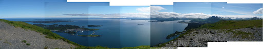 |
This picture is a much closer view of the airport. They actually have 3 runways, but only the really long one can be used for the commercial jets.  |
Here is a closer view of the commercial boat harbor where I have gone multiple times. I go out to the end of the dock furthest to the right. The little float in the middle of the picture and below the docks is where the sea lions like to lay in the sun.  |
Here is a picture showing the islands just offshore from town. Woody Island is the second one from the top, with the big deforested beach. The dining hall is the white building on Woody Island.  |
Here is a picture of Pillar Mountain that I took from the dock on Saturday morning. I think I was off the picture to the right when I was at the top of Pillar Mountain.  |
